Großer Gleichberg
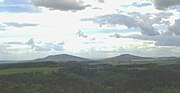
Mountain in GermanyAt 679 m above sea level (NHN), the Großer Gleichberg is the higher of the two adjacent mountaintops known as the Gleichberge east of Römhild in the landscape of Grabfeld and the county of Hildburghausen in the German state of Thuringia. It was formed in the Tertiary volcanic field of the Heldburger Gangschar and is the highest point today of that formation.
Read article


Top Questions
AI generatedMore questions
Nearby Places

Römhild
Town in Thuringia, Germany
Gleichamberg
Ortsteil of Römhild in Thuringia, Germany

Dingsleben
Municipality in Thuringia, Germany
Gleichberge (Verwaltungsgemeinschaft)
Spring (Milz)
River in Thuringia, Germany
Gleichberge
Mountain range in Germany

Kleiner Gleichberg
Mountain in Germany
Oppidum Steinsburg